

North Atlantic Overview
Summary
3/20/2025
8 min read
Edit: Blue Spruce Routes are deleted! Operations below the NAT HLA are unaffected. See this article for details.
Crossing the Atlantic outside of the NAT HLA can be accomplished between FL200 and FL280. Below FL200, you start to lose VHF communication and radar coverage. Above FL285 up to FL420 (the NAT HLA), additional navigation, communication, and surveillance equipment requirements and authorizations (LOAs) are needed to operate legally. Above FL420, the requirements start to drop off again.
NAT Doc 007 is the primary, condensed source of information for crossing the North Atlantic. It is available here.

Details
North Atlantic Airspace (NAT)
Flying within Oceanic airspace vastly differs from flying within domestic or European airspace. Outside of radio navigation range and radar coverage, different operational procedures are implemented to ensure proper separation between aircraft for normal and contingency ops. The NAT is the busiest oceanic airspace and has some unique operational requirements in and of itself.
This article intends to orient you to the NAT structure, geography, and altitude requirements for operations.
NAT Doc 007, prepared by the ICAO European and North Atlantic Office, is the best resource for learning about North Atlantic Operations. For your orientation, the material below is divided into two major sections: information for all operators and information specific to small operators (those without HF, Datalink, or advanced LOAs flying along the Blue Spruce Routes - now Iceland-Greenland Corridor, below FL290).
All Operators
Oceanic operations can be broadly divided into in three layers: Navigation, Communication, and Surveillance.
Navigation
The NAT consists of six Oceanic Control Areas (OCAs), as shown on the map. These are like your ATC centers. Unlike domestic ops, however, you don't communicate directly with them; more info later. The majority of NAT Doc 007 is dedicated to operations in the North Atlantic High Level Airspace (NAT HLA) from FL285-FL420 (NAT Doc 007 1.1.1)

The main route structure, the Organized Track System (OTS) is layered over the NAT. If you are not on a defined route, you are flying a "Random Route." Where you fly and your altitude affect your required authorizations and equipment requirements. Technically, there are more routes running north and south off the coast of Spain and France (T9 and T290), and a few odd ones around Greenland and Iceland. And of course, the former Blue Spruce Routes are now deleted.

NAT Tracks on Foreflight US IFR Ocean map layer
The Organized Track System is the primary means of crossing the Atlantic—most traffic is airliners. The routing changes every day because OCAs optimize these routes for winds and military airspace operations. Two flows dominate the NAT. In the morning, flights leave Europe for the Americas, called the westbound or day tracks. Conversely, in the evening, flights leave the Americas for Europe, called the eastbound or night tracks. Starting at the far North, the tracks are identified as A, B, C, etc., for traffic flying West, and at the far South, the tracks are Z, Y, X, etc., for traffic flying East.
The most efficient tracks, the core tracks, are in the middle of the respective East and West flows. These are called the Performance Based Communication and Surveillance (PBCS) tracks. Separation standards on these tracks are the tightest, and accessing these optimized routes requires the highest authorizations (LOAs).
Lastly, all routes, including random routes, are a combination of lat-long waypoints and GPS waypoints. A route across the Atlantic would begin at a GPS entry waypoint at the Flight Information Region (FIR) boundary, called the Oceanic Entry Point (OEP). Then, the route would consist of lat-longs, might include an NDB over Greenland, and end with another GPS waypoint exiting the FIR on the far side, called the Oceanic Exit Point (OEP).
For Example:

Navigating altitude in the NAT is also more complicated, and the airspace has several levels to be aware of. The previously mentioned tracks run from FL340 to FL400. The tracks are contained within a more extensive layer called the North Atlantic High Level Airspace (NAT HLA) from FL290 to FL410. Flying in the NAT HLA requires a few special authorizations: RVSM, NAT HLA, and RNP 4 (or 10, depending on your route/track). Read here for a breakdown on what LOAs you need for the airspace.
Key takeaway: without those LOAs, you are limited to FL280 and below unless you can get above FL420.
Altitude floors vary. Generally, flights above 5500 ft are in controlled airspace, and an IFR flight plan is needed. Controlled airspace above Nuuk (Greenland) does not start until FL195 and up.
Communication
Six aeronautical radio stations relay VHF and HF communications to the OCAs (5.1.5). The radio stations correspond to the OCAs in geography and mostly in name, Reykiyavik OCA and Iceland Radio being the exception. Radio is who you talk to for providing position reports and requesting altitude or route changes. Radio then relays to the OCAs and gets back to you with instructions.
Across the airspace, the emergency frequency 121.5 and the air-to-air frequency 123.45 are available as secondary communication means (5.2). All radio stations and aircraft should monitor these, which can be a potential means of relaying radio transmissions via other aircraft if you are not getting direct contact with the radio station.
Sattilite-based Data Link systems (CPDLC) are a third means of communication. Usually found on mid-sized jets and up, this is a direct way to send and receive text messages with the OCA. It is so effective that there is now a Datalink Mandate (DLM) for all aircraft from FL285-FL420 except for a corridor over Iceland and Greenland (NAT Doc 1.7).

DLM Exclusion Corridor
Surveillance
The Datalink Mandate requires you to be equipped with CPDLC and ADS-C and have LOAs for operations. CPDLC + ADS-C + LOA A056 = FANS 1/A. FANS stands for Future Air Navigation Systems. The DLM exemption corridor exists because VHF coverage and ADS-B surveillance are reliable in this airspace. Outside the DLM, satellite-based CPDLC communication and ADS-C surveillance systems are required to meet appropriate separation standards.
The important takeaway is that if you do not have CPDLC or ADS-C equipment and corresponding LOAs, you are limited to below FL285, above FL420, or through the DLM exemption corridor. Notice the stars are aligning with both navigation and surveillance at these altitudes.
Small Operators
While most of NAT Doc 007 focuses on high flyers, nuggets for small operators are sprinkled throughout, including this gem from the Forward:
“Aircraft without NAT HLA or RVSM approvals may, of course, also fly across the North Atlantic below FL285. However, due consideration should be given to the particular operating environment. Especially by pilots/operators of single and twin engine aircraft. Weather conditions can be harsh; there are limited VHF radio communications and ground-based navigation aids; and the terrain can be rugged and sparsely populated. International General Aviation (IGA) flights at these lower levels constitute a very small percentage of the overall NAT traffic but they account for the vast majority of Search and Rescue operations."
You've been warned.
Navigation
The default requirement in the NAT HLA is to have two Long Range Navigation Systems (LRNS). To cross with one LRNS, you must fly along the Blue Spruce Routes Iceland-Greenland Corridor or fly above or below the NAT HLA. Note: if you have two GPS units but only one FMS input, that only counts as one LRNU.
Communication
4.2.12 states HF radios are required outside VHF coverage. However, some exceptions apply. The Canadians (i.e., Gander OCA) allow exemption from HF along the former Blue Spruce Routes. This allows aircraft to cross at lower altitudes without VHF coverage legally.
However, VHF coverage is pretty good above FL200. In the last decade, VHF and ADS-B coverage has improved significantly. During my last crossing, I experienced domestic-like communication throughout. The one spotty gap remaining is the midpoint between Goose Bay, Canada, and Narsarrsuaq, Greenland. VHF should be sufficient if you plan to fly between FL250 and FL280 on this route, and above FL200 works for the northern route passing through Iqaluit, Canada and Kangerlussuaq (Sondrestrom), Greenland or Nuuk, Greenland.
Adding an HF radio remains an option for a crossing. If your aircraft's range allows it, it would open up additional routes, such as through the Azores. You can check with your OEM for HF options, or Aviation HF has rentals. More information about required aircraft equipment can be found here.
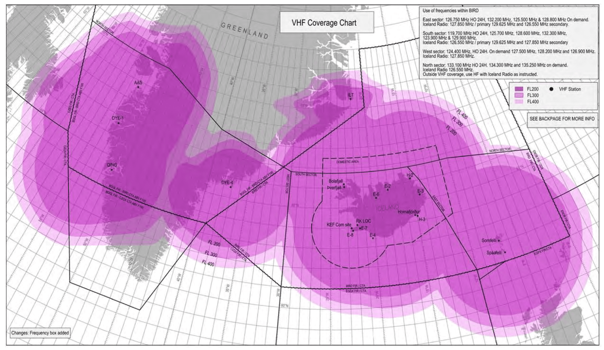
Reykjavik VHF Coverage Map
Surveillance
Radar and ADS-B coverage is limited due to those systems' ground-based nature. However, it has improved in recent years as ADS-B has been rolled out. The map below depicts areas where you can expect radar and ADS-B coverage in green. Notice how the green band matches the DLM exemption corridor. Note, these are official ground-based systems. Unofficially, the Canadians have space-based ADS-B receivers across the entire North Atlantic. So ATC can see where you are, but it's not used for aircraft separation purposes.
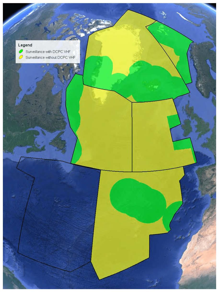
Radar and ADS-B Coverage Map
End Note
Tackling a crossing in small aircraft or large aircraft without authorization is an exception to the rules. Two LRNUs are required, but below FL285 or above FL420, you only need one. You must have radio comms over your whole route (HF), but former Blue Spruce routes (Iceland - Greenland Corridor) allow VHF only. Datalink is required unless you fly below FL285, above FL420, or the DLM exclusion area.
If you have greater equipment capabilities, by all means, pursue the additional authorizations and airspace access. If you do not, it is vital to understand the limits of where you can operate.
Final note: NAT Doc 007 Chapter 12 is written specifically for operations below FL290 through the NAT. The six pages are worth reading.
Aviate
Review Aircraft Equipment for a refresher on what equipment you need to complete the operation.
Review if you have the equipment to pursue the LOAs required to fly in the NAT HLA: A056 (Datalink), B036 (RNP 2/4/10), B039 (NAT HLA), and B046 (RVSM) at a minimum. Get C052 (GPS Approaches) and D195 (MEL) while you’re at it.
Read NAT Doc 007 Chapter 12
Navigate
Article 12 of 22 on your international operations journey. Eject at any time to land at international articles.


